Cumbres and Toltec Scenic Railroad
| Cumbres and Toltec Scenic Railroad | |
|---|---|
| Locale | Colorado, New Mexico |
| Dates of operation | 1970 – present |
| Track gauge | 3 ft (914 mm) |
| Headquarters | Chama, New Mexico |
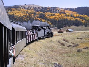
The Cumbres and Toltec Scenic Railroad (C&TS) is a narrow gauge heritage railway running between Antonito, Colorado and Chama, New Mexico. The track was originally laid in 1880 by the Denver and Rio Grande Railroad. Starting in 1970, the railroad began to take tourists on six-hour trips between the two towns, using steam locomotives. The railroad has also been featured in several movies, including Indiana Jones and the Last Crusade.
Today the C&TS Railroad is comprised of 64 miles of former Denver and Rio Grande Western trackage. While officially headquartered in Chama, New Mexico, the railroad splits most of its functions between the termini of the railroad. At its Antonito end, the Cumbres and Toltec Commission offices are headquartered, along with the railroad's main car shop, where repairs to rolling stock are performed. The main center of actual operation for the railroad is located in Chama, where the locomotive repair shop is located.
Most riders opt to leave from Chama, New Mexico, the southernmost point on the railroad. Chama today is a small village, but considered hallowed ground by many railfans. Chama now houses one of the most physically complete railroad yards in the country. Though portions of the roundhouse, warehouses, and parking lots have been changed, the railroad yard still has the feel of 1960 and earlier. The yard tracks are nearly filled to capacity with authentic rolling stock of the Denver and Rio Grande Western and indigenous to the railroad line. Even the locomotives of the railroad were built for the C&TS's precursor, all 2-8-2 Mikados. From the rare K-27 "Mudhen", #463, once owned by Gene Autry, to the homebuilt K-37s built by the D&RGW in 1929-30 in the railroad's Burnham Shops. The mainstay of the fleet, is the venerable K-36 fleet, turned out by Baldwin Locomotive Works in August 1925. The arguable "flagship" of the line is K-36, #487, which has seen the most service in the operation of the railroad.
Route details
Eastward to Osier
Beginning in Chama (milepost 344.12), the railroad makes a nearly straight shot in a northeasterly direction after leaving the yard, and crossing the Rio Chama. Over a mile and a half later, the 4% grade begins, from here to Cumbres, the grade is nearly constant, with one major exception at Coxo. The first siding on the line is located at Lobato (milepost 399.99); located here are the remnants of a stock pen and a water tank specifically made for a movie in the 1970s, though the tank would also be used in Indiana Jones and The Last Crusade. As of 2006, the water tower was knocked over, due to age and high winds. Just under a quarter of a mile away, is Lobato Trestle, this trestle is the second highest trestle on the line, and was erected in 1883. Due to Weight restrictions, only one locomotive at a time is allowed to cross the bridge at a single time; all double-headers on the line must separate, and recouple upon reaching the other side.
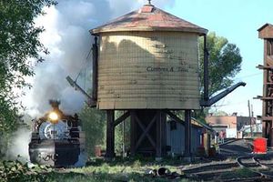
From here to Cumbres, the railroad operates on the north side of Wolf Creek. On the journey to the top at Cumbres, the train passes Cresco Siding and Water Tank (milepost 335.10) and navigates a small canyon past Hamilton's Point. Exiting the canyon, the tracks make a turn to the northwest and up the Wolf Creek drainage through Coxo. At a narrow point of the valley, the tracks make a horseshoe turn up to Windy Point, which the train rounds to enter Cumbres Pass.
Located at Cumbres (milepost 330.48), elevation 10,015 ft, is the car inspector's house, water standpipe, a remnant of the extensive snow shed, and the section house, which has replaced the original depot after it was demolished in the 1950s. From here eastward, the tracks head downward at a lesser grade, the ruling grade now is 2.5%, and descends the Cumbres Loop, more commonly refer to as "Tanglefoot Curve". After exiting the loop, the tracks follow a general westerly direction until milepost 327.6, where the tracks turn northwards up the Los Pinos Valley.
Heading northward, the tracks lose elevation, while the valley slopes upward, with the tracks and valley floor finally meeting at mile 325, where the tracks once again change direction, heading southward now, begin to follow the Rio de Los Pinos towards Osier. After mile 323, the tracks again leave the valley, on a much steeper grade, while the tracks cling to the valley created by the river. Along the way, the route will traverse Cascade Trestle (milepost 319.95), taller than the Loboto Trestle, at 137 ft. high, the Cascade Trestle is the highest on the line, and is built in the same construction as Lobato. Approximately a mile and a half later, the tracks enter Osier, Colorado, the mid-point of the railroad where the two trains meet for lunch. Here, riders may return to their point of origin, or switch trains and ride to the opposing terminus.
Westward To Osier
This section covers the eastern portion of the line from the small cattle town of Antonito to Osier, the midpoint of the line. Antonito (milepost 280.70) is a small company town of the former Denver and Rio Grande Railway, now Union Pacific. Here, the car shop, balloon loop, water tank, and other relics of the C&TS reside. The water tank was brought in from Lava (milepost 291.55) after the original water tank at Antonito burned in 1971. For a time firetrucks had to refuel the K-27, 36, and 37 locomotives that provide the motive power for the train. Most of the facilities were made by the Cumbres & Toltec, as the original rail yard, wye and station were not sold to the states of Colorado and New Mexico.
Shortly after leaving the station, the train heads straight for 3 miles, until coming into some hills. Shortly afterwards, the train crosses Ferguson's Trestle (milepost 285.87), made famous when a man by the same name was hung from a locomotive on the bridge. It was featured in the 1988 TV movie Where the Hell's That Gold?!!? starring Willie Nelson and Delta Burke. The bridge burned and traffic was halted for a week while the C&TS rebuilt the trestle. About three miles later, the train makes its first of 11 crossings into New Mexico, and climbs a ledge up to a lava mesa. Lava (291.55) makes a sharp turn, and the old tank from Antonito resides here. This is a reverse loop, used to turn the rotary snow plow trains from Chama.
The Cumbres and Toltec has two of the old rotary snow plows, Rotary OM and Rotary OY. Rotary ON is in a scrap heap next to the rails of the White Pass and Yukon Route Railroad, while other Rio Grade rolling stock also reside there. Heading west, the train traverses Whiplash Curve. About a mile from Whiplash Curve lie the sidings and wye facilities of Big Horn. Past Big Horn the train loops around the sides of mountains going through horseshoe curves before reaching the 1st water stop at Sublette.
Sublette is an abandoned section camp on the railroad, consisting of a log bunk house, a section house, a siding and other buildings. There used to be a water tank at the western end of the siding, and now in its place is a stand pipe. After filling its tender with water, the engine and the train slowly creep into the lush aspen groves.


