Streetcars in New Orleans
| St. Charles Avenue Streetcar, Riverfront Line, Canal Street Line | |
|---|---|
| Locale | New Orleans, LA |
| Dates of operation | September 26, 1835 – present |
| Track gauge | 5 ft 2½ in (1588 mm); converted from 4 ft 8½ in (1435 mm) (standard gauge) in 1929 |
| Headquarters | New Orleans, LA |
Streetcars in New Orleans have been an integral part of the city's public transportation network since the first half of the 19th century. The longest of New Orleans' streetcar lines, the St. Charles Avenue Streetcar, is the oldest continuously operating street railway system in the world, according to the American Society of Mechanical Engineers. Today, the streetcars are operated by the New Orleans Regional Transit Authority (RTA).
There are currently three operating streetcar lines in New Orleans: The St. Charles Avenue Line, the Riverfront Line, and the Canal Street Line. The St. Charles Avenue Line is the only line that has operated continuously throughout New Orleans' streetcar history. All other lines, were bustituted in the period from the late 1940s to the early 1960s; preservationists were unable to save the streetcars on Canal Street, but were able to convince the city government to protect the St. Charles Avenue Line by granting it historic landmark status. In the later 20th century, trends began to favor rail transit again. A short Riverfront Line started service in 1988, and service returned to Canal Street in 2004, 40 years after it had been shut down.
The wide destruction wrought on the city by Hurricane Katrina in September 2005 knocked all three lines out of operation and damaged many of the streetcars. Service on a portion of the Canal Street line was restored in December of that year, with the remainder of the line and the Riverfront line returning to service in early 2006. As of December 2006, temporary buses are still running on the St. Charles line, though service has been restored to part of the line.
Contents
Current lines
St. Charles Avenue Line
The St. Charles Avenue Line starts uptown, at Carrollton Avenue and Claiborne Avenue. It runs on Carrollton Avenue through the Carrollton neighborhood towards the Mississippi River, then near the river levee turns on to Saint Charles Avenue. It proceeds past entrances to Audubon Park, Tulane University and Loyola University New Orleans, continues through Uptown New Orleans including the Garden District, and ends at Canal Street in the New Orleans Central Business District at the edge of the French Quarter, a distance of about fifteen miles.
History of the line
Planing for the line began in 1831, and work began as the "New Orleans and Carrollton Rail Road" in February 1833, the second railway in Greater New Orleans after the Pontchartrain Rail Road. Service began on September 26, 1835, originally without a dedicated right-of-way (it ran on public streets) although one was eventually established in the neutral ground (the median). Passenger and freight cars were hauled by steam locomotive. As the area along the line became more urbanized, objections to the soot and noise produced by the locomotive increased, and transport was switched to cars were powered by horses and mules. For decades in the late 19th century, desire for a mode of transit more swift and powerful than horses but without the disruptive effects of locomotives resulted in a number of systems being tried out. Experimental systems included overhead cables propulsion (with a cable clamp patented by P.G.T. Beauregard in 1869 later being adapted for the San Francisco cable car system), and several innovative designs by Dr. Emile Lamm, including ammonia engines, a "Chlorine of Calcium Engine", and most successfully the Lamm Fireless Engine which not only propelled pairs of cars along the line in the 1880s but was adapted by the street railways of Paris. While the city's first experiments with electric powered cars was made in 1884 (in conjunction with the World Cotton Centennial World's Fair), electric streetcars were not considered sufficiently perfected for widespread use until the following decade, and the line was electrified February 1, 1893.
In 1922 the New Orleans & Carrollton Rail Road was sold to New Orleans Public Service Incorporated ("NOPSI"), which consolidated the city's various streetcar lines and electrical production.
In 1972 automatic fairboxes were introduced, and the job of a separate conductor was eliminated from streetcars.
The line still has one of the 1890s vintage cars in running condition, although it is not used for regular passenger service. The bulk of the line's cars date from the 1920s.
Further reading
- The Saint Charles Streetcar -- or the history of The New Orleans and Carrollton Railroad, by James Gilbeau, 3rd edition 1992, Louisiana Landmarks Society
Riverfront Line
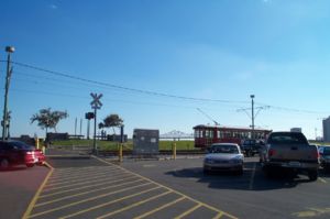
The Riverfront Line was built along a section of the city's Mississippi River coastline, in an area with many amenities catering to tourists. It opened in 1988. The line is the city's shortest, running 2 miles from Calliope Street at the upper end of the New Orleans Convention Center to the downriver (far) end of the French Quarter at the foot of Esplanade Avenue. Unlike the other two lines, it travels on an exclusive right of way, along the River levee beside New Orleans Belt Railway tracks.
Some old trams formerly running along the Canal line until the 1960s were repurchased and refurbished, with additional cars imported from Australia. It was the city's first streetcar line to offer handicapped access; the historic landmark status of the Saint Charles route prevented the modification of the cars on that line.
Canal Street Line
The Canal Streetcar route dated back to 1861. Discontinued in 1964 over the protests of preservationists, the Canal streetcar line reopened in 2004.
The Canal St. Streetcar, in its reconception, now includes two lines. The main line, named after the original "Cemeteries" line, travels a direct route from the foot of Canal St. at the Mississippi River to its head 3 miles inland. For much of its history, this area constituted the northern (lakeside) boundary of the city, which explains the density of cemeteries, Catholic, Protestant, and Jewish, in this area. The other, designated "City Park", begins at the French Market at the foot of Esplanade and Elysian Fields Avenues, sharing trackage with the Riverfront Line before turning onto Canal Street for most of its length. It diverges from the main trackage at Carrollton Avenue, where it turns on to N. Carrollton Avenue, ending at Beauregard Circle, at Esplanade Avenue and Bayou St. John, near the entrance of the New Orleans Museum of Art and within easy walking distance of the New Orleans Fairgrounds, site of the yearly Jazz and Heritage Festival.
Further reading
- New Orleans: The Canal Streetcar Line by Edward J. Branley, Arcadia Publishing
History
In 1902, there was protest when the Louisiana legislature mandated that public transportation must enforce racial segregation. At first this was objected to by both white and black riders as an inconvenience, and by the streetcar companies on grounds of both added expense and the difficulties of determining the racial background of some New Orleanians.
In 1929, there was a wide spread strike by transit workers demanding better pay which was widely supported by much of the public. Sandwiches on baguettes were given to the "poor boys" on strike, said to be the origin of the local name of "po' boy" sandwiches.
During World War II, a few old mule drawn cars were returned to service on a few shorter lines as an energy saving measure. After the war, as with much of the United States, many streetcar lines were replaced with buses.
Hurricane Katrina
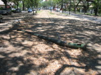
The area through which the St. Charles Avenue Line travelled fared comparatively well in Hurricane Katrina's devastating impact on New Orleans at the end of August, 2005, with moderate flooding only of the two ends of the line at Claiborne Avenue and at Canal Street. However, wind damage and falling trees took out many sections of catenary along St. Charles Avenue, and vehicles parked on the neutral ground over the inactive tracks have degraded parts of the right-of-way. At the start of October, 2005, as this part of town started being repopulated, bus service began running on the St. Charles line. The section running from Carondelet Street to Lee Circle in the Central Business District was restored December 19th 2006 at 10:30am Central time , with the rest of the line to be restored by late 2007. The time is needed to repair the damage caused by Hurricane Katrina and to perform other maintenance and upgrades to the lines that was scheduled before the hurricane; leaving the line shut down and electrical system unpowered will allow the upgrades to be performed more safely and easily.
Perhaps more serious was the effect on the system's rolling stock. The vintage streetcars rode out the storm in the sealed barn in a portion of Old Carrollton that didn't flood, and are undamaged. However, the new cars were in a different barn that did flood, and all of them were rendered inoperable; current estimates are that they may cost up to $1 million a car to restore.
Service on the Canal Street Line was restored in December 2005, with several historic cars have been transferred to serve there while the flood-damaged cars are being repaired. In December of 2006, partial service was restarted on the St. Charles line, between Canal St. and Lee Circle. The eventual reopening of all lines is a major priority for the city as it rebuilds.
Historic lines
Template:Sect-stub In the late 19th and early 20th century, the city had dozens of lines, including:
- Claiborne Avenue
- Desire Street -- the line was immortalized in Tennessee Williams' play A Streetcar Named Desire. The line was converted to busses in 1948. Various proposals to revive the streetcar line have been discussed in recent years.
- Esplanade Avenue
- Felicity Street
- Jackson Avenue
- Louisiana Avenue
- Magazine Street
- Maple Street
- Napoleon Avenue (resurrection being considered)
- once longest line in New Orleans, stretching from Napoleon and Tchoupitoulas, along Napoleon, Washington, and Palmetto, then down Metairie Rd. to Shrewsbury
- Orleans Avenue
- Rampart Street -- line discontinued in 1947.
- Royal Street
- St. Claude Avenue (resurrection being considered as new "Desire" line)
- Tchoupitoulas Street
- Tulane Avenue (St. Charles-Tulane Belt)
- Orleans/Kenner streetcar line -- the line operated between 1915-1931 and connected New Orleans to Kenner. The line ran between the intersection of Rampart and Canal in New Orleans and the intersection of Williams Blvd and Jefferson Hwy in Kenner.[1]
Current rolling stock
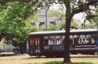
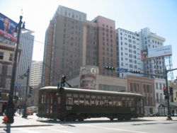
The St. Charles Avenue Line has traditionally used streetcars of the type that were common all over the United States in the early parts of the 20th century. Most of the streetcars that were running on this line before Katrina were Perley Thomas cars dating from the 1920s. One 1890s vintage streetcar is still in running condition; it is used for maintenance and special uses. Unlike most North American cities with streetcar systems, New Orleans never adopted PCC cars in the 1930s or 1940s, and never traded in older streetcars for modern light rail vehicles in the later 20th century.
In the Carrollton neighborhood, the RTA has a streetcar barn where the streetcars of the city's lines are stored and maintained. The shop there has become adept at duplicating any part needed for the vintage cars.
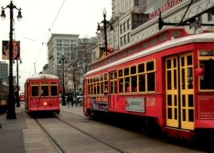
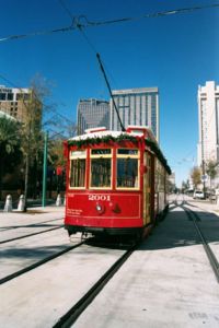
With the addition of the two new lines, more vehicles were needed for the system. The RTA's shops converted some modern streetcars into near duplicates in appearance of the older cars, and built a number of others from scratch. These new cars can be distinguished from the vintage vehicles by their bright red color; unlike the older cars, they are air conditioned and ADA-compliant.
Before Hurricane Katrina, the historic cars ran exclusively on the St. Charles Avenue Line, and the newer cars on the other two lines. However, in the wake of hurricane damage to both the tracks and the cars, such vehicles and infrastructure as are functional run where possible until full repairs can be made.
References
External links
| Wikimedia Commons has media related to: Trams in New Orleans |
