File:Carrollton-viaduct.jpg
From TrainSpottingWorld, for Rail fans everywhere
No higher resolution available.
Carrollton-viaduct.jpg (474 × 345 pixels, file size: 36 KB, MIME type: image/jpeg)
Summary
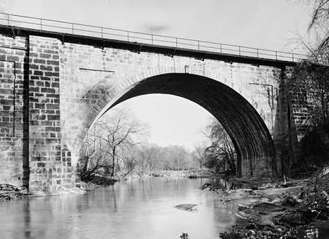
Carrollton Viaduct in Baltimore, Maryland. . View of the west side. Image cropt from Historic American Engineering Record photograph (No. HAER MD,4-BALT,129-2) by William Edmund Barrett, taken in 1970 or 1971. [1]
Licensing
| This work is in the public domain in the United States because it is a work of the United States Federal Government under the terms of Title 17, Chapter 1, Section 105 of the |US Code. See Copyrights.
Note: This only applies to works of the Federal Government and not to the work of any individual US state, territory, commonwealth, county, subdivision, or municipality. |
 |
| This article is licensed under the GNU Free Documentation License. It uses material from the Wikipedia article "Carrollton-viaduct.jpg". |
File history
Click on a date/time to view the file as it appeared at that time.
| Date/Time | Thumbnail | Dimensions | User | Comment | |
|---|---|---|---|---|---|
| current | 12:37, 21 December 2007 | | 474 × 345 (36 KB) | DP67 (talk | contribs) | == Summary == Carrollton Viaduct in Baltimore, Maryland. {{coor dms|39|16|32|N|76|39|18|W|}}. View of the west side. Image cropt from Historic American Engineering Record photograph (No. HAER MD,4-BALT,129-2) by William Edmund Barrett, taken in 1970 or 1971. [http://memory.loc.gov/pnp/habshaer/md/md0900/md0908/photos/086090pr.jpg] == Licensing == {{PD-USGov}} {{From Wikipedia}} Category:Images of places listed on the United States National Register of Historic Places Category:Images of Baltimore, Maryland |
- You cannot overwrite this file.
File usage
The following 2 pages link to this file:

![[1]](http://memory.loc.gov/pnp/habshaer/md/md0900/md0908/photos/086090pr.jpg)