File:City of New Orleans shift map.svg
From TrainSpottingWorld, for Rail fans everywhere

Size of this PNG preview of this SVG file: 270 × 479 pixels. Other resolution: 135 × 240 pixels.
Original file (SVG file, nominally 573 × 1,017 pixels, file size: 47 KB)
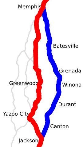
Template:Spuimap Map of the 1995 shift of the City of New Orleans from the Grenada District to the Yazoo District. Traced on USGS topos.
File history
Click on a date/time to view the file as it appeared at that time.
| Date/Time | Thumbnail | Dimensions | User | Comment | |
|---|---|---|---|---|---|
| current | 20:04, 15 February 2007 | | 573 × 1,017 (47 KB) | Admin (talk | contribs) | {{spuimap}} Map of the 1995 shift of the ''City of New Orleans'' from the Grenada District to the Yazoo District. Traced on USGS topos. Category:Railroad maps of the United States Category:Amtrak Category:Illinois Central Railroad |
- You cannot overwrite this file.
File usage
The following page links to this file:
