File:YukonWhitePassRailmap.png
From TrainSpottingWorld, for Rail fans everywhere
Size of this preview: 395 × 480 pixels. Other resolutions: 197 × 240 pixels | 396 × 481 pixels.
Original file (396 × 481 pixels, file size: 11 KB, MIME type: image/png)
Summary
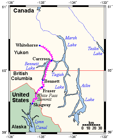
Map showing the railway's route through Alaska, British Columbia and the Yukon. This map's source is here, with the uploader's modifications, and the GMT homepage says that the tools are released under the GNU General Public License.
Licensing

I, the creator of this work, hereby grant the permission to copy, distribute and/or modify this document under the terms of the GNU Free Documentation License, Version 1.2 or any later version published by the Free Software Foundation; with no Invariant Sections, no Front-Cover Texts, and no Back-Cover Texts.
Subject to disclaimers.
File history
Click on a date/time to view the file as it appeared at that time.
| Date/Time | Thumbnail | Dimensions | User | Comment | |
|---|---|---|---|---|---|
| current | 01:52, 16 February 2007 | | 396 × 481 (11 KB) | Admin (talk | contribs) | == Summary == Map showing the railway's route through Alaska, British Columbia and the Yukon. This map's source is [http://www.aquarius.geomar.de/omc/make_map.html here], with the uploader's modifications, and the [http://gmt.soest.hawaii.edu/ GMT homepage] says that the tools are released under the GNU General Public License. == Licensing == {{GFDL-self}} |
- You cannot overwrite this file.
File usage
The following page links to this file:
