File:RNPLineRepresentation.svg

Summary
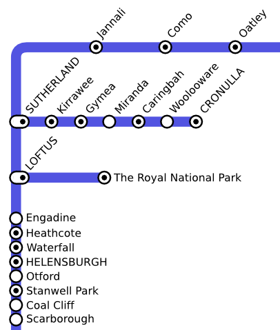
A representation from the 1985 State Rail network map, showing the Royal National Park Branch Line.
Source
Produced by wp:User:Tntnnbltn based on a map available from NSW Rail Historical Timelines. The original map is copyright RailCorp (the successor of State Rail), or the author of website "NSW Historical Timetables" if the map is not copyrighted.
Licensing
 Permission is granted to copy, distribute and/or modify this document under the terms of the GNU Free Documentation License, Version 1.2 or any later version published by the Free Software Foundation; with no Invariant Sections, no Front-Cover Texts, and no Back-Cover Texts.
|
File history
Click on a date/time to view the file as it appeared at that time.
| Date/Time | Thumbnail | Dimensions | User | Comment | |
|---|---|---|---|---|---|
| current | 06:45, 16 February 2007 | | 417 × 492 (65 KB) | Admin (talk | contribs) | == Summary == A representation from the 1985 State Rail network map, showing the Royal National Park Branch Line. ==Source== Produced by wp:User:Tntnnbltn based on a map available from [http://www.geocities.com/nswrail/Pages/Maps/GSSMap11.jpg NSW Rail Historical Timelines]. The original map is copyright RailCorp (the successor of State Rail), or the author of website "NSW Historical Timetables" if the map is not copyrighted. == Licensing == {{self|GFDL|cc-by-sa-2.5,2.0,1.0}} |
- You cannot overwrite this file.
File usage
The following 2 pages link to this file:
