File:NelsonAndFortSheppardRailway.png
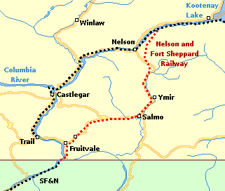
Route of Nelson and Fort Sheppard Railway in southern British Columbia, Canada.
Created by wp:User:Al guy on January 9, 2005 and released under the GFDL. Map drawn in GIMP. Underlying data © 2003. Government of Canada with permission from Natural Resources Canada and used under license.
See wp:User:Al guy/maps for more information on how the map was created.

Permission is granted to copy, distribute and/or modify this document under the terms of the GNU Free Documentation License, Version 1.2 or any later version published by the Free Software Foundation; with no Invariant Sections, no Front-Cover Texts, and no Back-Cover Texts.
Subject to disclaimers.
File history
Click on a date/time to view the file as it appeared at that time.
| Date/Time | Thumbnail | Dimensions | User | Comment | |
|---|---|---|---|---|---|
| current | 03:28, 16 February 2007 | | 321 × 272 (10 KB) | Admin (talk | contribs) | Route of Nelson and Fort Sheppard Railway in southern British Columbia, Canada. Created by wp:User:Al guy on January 9, 2005 and released under the GFDL. Map drawn in GIMP. Underlying data © 2003. Government of Canada with permission from Natural Resources Canada and used under [http://geogratis.cgdi.gc.ca/e_license.html license]. See wp:User:Al guy/maps for more information on how the map was created. {{GFDL}} |
- You cannot overwrite this file.
File usage
The following page links to this file:
