File:NEC map.svg
From TrainSpottingWorld, for Rail fans everywhere

Size of this PNG preview of this SVG file: 625 × 480 pixels. Other resolution: 313 × 240 pixels.
Original file (SVG file, nominally 1,676 × 1,286 pixels, file size: 239 KB)
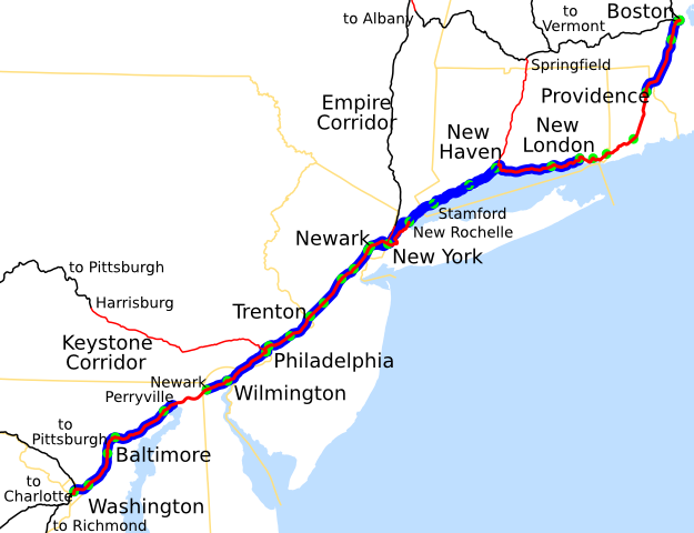
Template:Spuimap Map of the Northeast Corridor, traced on USGS topos.
Legend:
- Red - Amtrak ownership
- Blue - NEC commuter services and NEC commuter rail agency ownership
- Black - off-NEC Amtrak lines not owned by Amtrak
- Green - stations on the NEC (Amtrak only)
File history
Click on a date/time to view the file as it appeared at that time.
| Date/Time | Thumbnail | Dimensions | User | Comment | |
|---|---|---|---|---|---|
| current | 03:44, 16 February 2007 | | 1,676 × 1,286 (239 KB) | Admin (talk | contribs) | {{spuimap}} Map of the Northeast Corridor, traced on USGS topos. Legend: *Red - Amtrak ownership *Blue - NEC commuter services and NEC commuter rail agency ownership *Black - off-NEC Amtrak lines not owned by Amtrak *Green - stations on the NEC (Amtrak only) Category:Railroad maps of the United States Category:Amtrak Category:Pennsylvania Railroad Category:New York, New Haven and Hartford Railroad |
- You cannot overwrite this file.
File usage
The following 2 pages link to this file:
