File:Island ga map-pre-w.png
From TrainSpottingWorld, for Rail fans everywhere
Size of this preview: 640 × 169 pixels. Other resolutions: 320 × 85 pixels | 1,071 × 283 pixels.
Original file (1,071 × 283 pixels, file size: 22 KB, MIME type: image/png)
Summary
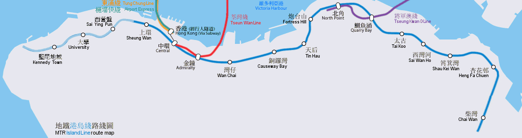
地鐵港島綫路線圖(按真實地形繪畫), 包含西港島延綫
Geographically accurate map of the MTR Island Line, including the proposed West Island extension.
By Bus_28a, Mtrkwt (Island Line united style version by User:Sameboat)
Licensing
 Permission is granted to copy, distribute and/or modify this document under the terms of the GNU Free Documentation License, Version 1.2 or any later version published by the Free Software Foundation; with no Invariant Sections, no Front-Cover Texts, and no Back-Cover Texts.
|
File history
Click on a date/time to view the file as it appeared at that time.
| Date/Time | Thumbnail | Dimensions | User | Comment | |
|---|---|---|---|---|---|
| current | 01:01, 16 February 2007 | 1,071 × 283 (22 KB) | Admin (talk | contribs) | == Summary == 地鐵港島綫路線圖(按真實地形繪畫), 包含西港島延綫 Geographically accurate map of the MTR Island Line, including the proposed West Island extension. By Bus_28a, Mtrkwt (Island Line united style version by User:Sameboat) == Licensing == {{self|GFDL|cc-by-sa-2.5,2.0,1.0}} |
- You cannot overwrite this file.
File usage
The following 2 pages link to this file:
