File:Tyne and Wear Metro map (proposed from Dec 2005).gif
From TrainSpottingWorld, for Rail fans everywhere

Size of this preview: 640 × 456 pixels. Other resolutions: 320 × 228 pixels | 1,215 × 865 pixels.
Original file (1,215 × 865 pixels, file size: 32 KB, MIME type: image/gif)
Beschreibung
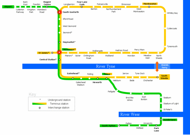
- Description: Map of the Tyne and Wear Metro, proposal December 2005
- Author: Johnwalton
- Date: 2005
- Source: English Wikipedia
- License: GFDL
- Beschreibung: Karte der Tyne and Wear Metro mit Stand Dezember 2005
- Autor: Johnwalton
- Datum: 2005
- Quelle: Englische Wikipedia
- Lizenz: GFDL
History (from en.wikipedia.org)
- (del) (cur) 21:13, 19 November 2005 . . Johnwalton (Talk) . . 1215x865 (32810 bytes) (Green line will run Airport - Sunderland - South Hylton (6 per hour, with 3 trains terminating at Sunderland and 3 continuing to South Hylton each hour) Yellow line will run St James - South Shields via the Coast (6 trains per hour) Additional peak hour)
- (del) (rev) 09:06, 20 August 2005 . . Johnwalton (Talk) . . 1219x822 (30262 bytes) (Added Northumberland Park station, as it is due to open December 2005)
- (del) (rev) 16:21, 27 May 2005 . . Johnwalton (Talk) . . 1201x855 (30240 bytes) (corrected version {{GFDL}} )
- (del) (rev) 16:18, 27 May 2005 . . Johnwalton (Talk) . . 1201x855 (30356 bytes) (Reverted to earlier revision)
- (del) (rev) 16:16, 27 May 2005 . . Johnwalton (Talk) . . 1201x855 (30240 bytes)
- (del) (rev) 16:05, 27 May 2005 . . Johnwalton (Talk) . . 1201x855 (30356 bytes) (Proposed changes to Tyne and Wear Metro services to be effective from 11th December 2005.)
Licensing
File history
Click on a date/time to view the file as it appeared at that time.
| Date/Time | Thumbnail | Dimensions | User | Comment | |
|---|---|---|---|---|---|
| current | 01:22, 16 February 2007 | | 1,215 × 865 (32 KB) | Admin (talk | contribs) | == Beschreibung == {{English}} * Description: Map of the Tyne and Wear Metro, proposal December 2005 * Author: Johnwalton * Date: 2005 * Source: [http://en.wikipedia.org/wiki/Image:Tyne_and_Wear_Metro_map_%28proposed_from_Dec_2005%29.gif English Wikipedia] * License: GFDL {{Deutsch}} * Beschreibung: Karte der Tyne and Wear Metro mit Stand Dezember 2005 * Autor: Johnwalton * Datum: 2005 * Quelle: [http://en.wikipedia.org/wiki/Image:Tyne_and_Wear_Metro_map_%28proposed_from_Dec_2005%29.gif Englische Wikipedia] * Lizenz: GFDL == History (from en.wikipedia.org) == * (del) (cur) 21:13, 19 November 2005 . . Johnwalton (Talk) . . 1215x865 (32810 bytes) (Green line will run Airport - Sunderland - South Hylton (6 per hour, with 3 trains terminating at Sunderland and 3 continuing to South Hylton each hour) Yellow line will run St James - South Shields via the Coast (6 trains per hour) Additional peak hour) * (del) (rev) 09:06, 20 August 2005 . . Johnwalton (Talk) . . 1219x822 (30262 bytes) (Added Northumberland Park station, as it is due to open December 2005) * <nowiki>(del) (rev) 16:21, 27 May 2005 . . Johnwalton (Talk) . . 1201x855 (30240 bytes) (corrected version {{GFDL}} )</nowiki> * (del) (rev) 16:18, 27 May 2005 . . Johnwalton (Talk) . . 1201x855 (30356 bytes) (Reverted to earlier revision) * (del) (rev) 16:16, 27 May 2005 . . Johnwalton (Talk) . . 1201x855 (30240 bytes) * (del) (rev) 16:05, 27 May 2005 . . Johnwalton (Talk) . . 1201x855 (30356 bytes) (Proposed changes to Tyne and Wear Metro services to be effective from 11th December 2005.) == Licensing == {{GFDL-en}} Category:Tyne and Wear Metro maps |
- You cannot overwrite this file.
File usage
The following page links to this file:

.gif&oldid=5932)
.gif)
.gif&action=edit&redlink=1)
.gif&action=edit)
.gif&action=history)
.gif)
.gif)
.gif&printable=yes)
.gif&oldid=5932)
.gif&action=info)