File:The Circle Routes of Victorian London.png
From TrainSpottingWorld, for Rail fans everywhere

Size of this preview: 545 × 480 pixels. Other resolutions: 273 × 240 pixels | 2,029 × 1,787 pixels.
Original file (2,029 × 1,787 pixels, file size: 203 KB, MIME type: image/png)
Summary
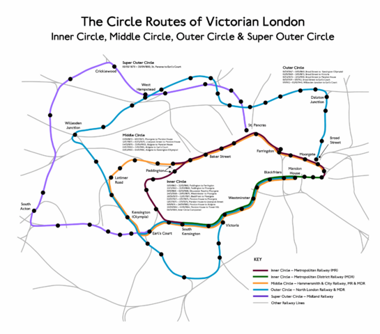
Map of the Circle Routes of Victorian London showing:
Licensing

I, the creator of this work, hereby grant the permission to copy, distribute and/or modify this document under the terms of the GNU Free Documentation License, Version 1.2 or any later version published by the Free Software Foundation; with no Invariant Sections, no Front-Cover Texts, and no Back-Cover Texts.
Subject to disclaimers.
File history
Click on a date/time to view the file as it appeared at that time.
| Date/Time | Thumbnail | Dimensions | User | Comment | |
|---|---|---|---|---|---|
| current | 01:03, 16 February 2007 | | 2,029 × 1,787 (203 KB) | Admin (talk | contribs) | ==Summary== Map of the Circle Routes of Victorian London showing: *Inner Circle *Middle Circle *Outer Circle *Super Outer Circle == Licensing == {{GFDL-self}} Category:WikiProject Underground images |
- You cannot overwrite this file.
File usage
The following page links to this file:
