File:North-london-line-diagram.svg
From TrainSpottingWorld, for Rail fans everywhere

Size of this PNG preview of this SVG file: 260 × 479 pixels. Other resolution: 130 × 240 pixels.
Original file (SVG file, nominally 320 × 590 pixels, file size: 59 KB)
Summary
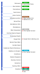
Line map of the North London Line showing interchanges and travelcard zones.
Created in Inkscape. The alignment of the station names appears to change during upload -- if anyone can fix it please do :)
Licensing

I, the creator of this work, hereby grant the permission to copy, distribute and/or modify this document under the terms of the GNU Free Documentation License, Version 1.2 or any later version published by the Free Software Foundation; with no Invariant Sections, no Front-Cover Texts, and no Back-Cover Texts.
Subject to disclaimers.
File history
Click on a date/time to view the file as it appeared at that time.
| Date/Time | Thumbnail | Dimensions | User | Comment | |
|---|---|---|---|---|---|
| current | 05:50, 16 February 2007 | | 320 × 590 (59 KB) | Admin (talk | contribs) | == Summary == Line map of the North London Line showing interchanges and travelcard zones. Created in Inkscape. The alignment of the station names appears to change during upload -- if anyone can fix it please do :) == Licensing == {{GFDL-self}} |
- You cannot overwrite this file.
File usage
The following page links to this file:
