File:Ligne de la Côte Fleurie.png
From TrainSpottingWorld, for Rail fans everywhere
Size of this preview: 411 × 479 pixels. Other resolutions: 206 × 240 pixels | 605 × 705 pixels.
Original file (605 × 705 pixels, file size: 9 KB, MIME type: image/png)
User:Captain Scarlet/information
Licensing
 Permission is granted to copy, distribute and/or modify this document under the terms of the GNU Free Documentation License, Version 1.2 or any later version published by the Free Software Foundation; with no Invariant Sections, no Front-Cover Texts, and no Back-Cover Texts.
|
File history
Click on a date/time to view the file as it appeared at that time.
| Date/Time | Thumbnail | Dimensions | User | Comment | |
|---|---|---|---|---|---|
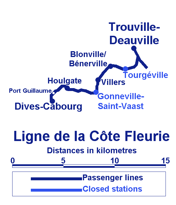
| current | 01:42, 16 February 2007 | | 605 × 705 (9 KB) | Admin (talk | contribs) | {{User:Captain Scarlet/information| |Description= Plan of the ligne de la Côte Fleurie in Basse-Normandie, France. |Source= Own work |Date= 10th October 2006 |Author= Gregory Deryckère |Permission= Attribution-ShareAlike 2.5 |other_versions= }} == Licensing == {{self2|GFDL|cc-by-2.5}} Côte |
- You cannot overwrite this file.
File usage
The following 2 pages link to this file:
