File:Kansaspacificgrants.jpg
Historic map of the Kansas Pacific Railway lines in the western U.S.
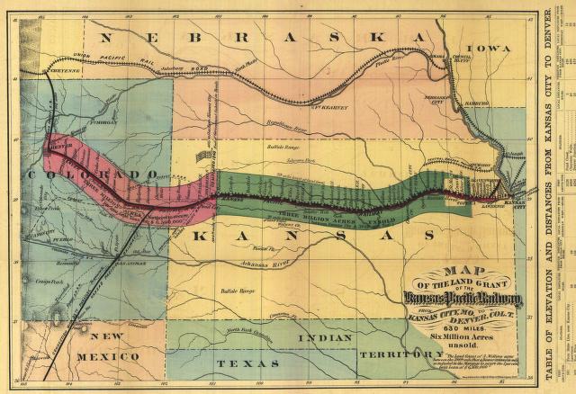
The map is entitled Map of the Land Grant of the Kansas Pacific Railway, from Kansas City, Mo. to Denver Col. T.. It was made in 1869 by Henry Seibert & Bros. The original map is 28 x 40 cm. In addition to the rail line, the map shows Native American habitation and bison ranges. The line between Kansas City (east) and Denver (west) is separated into the two sections (the western extension to Colorado was built in 1879, several years after the eastern section). The coloration indicates the extent of the land grants on either side of the rail line.
source: Digitized Kansas maps from the University of Wichita
This image is in the public domain in the United States. In most cases, this means that it was first published in the United States prior to January 1, 1923 . Other jurisdictions may have other rules, and this image might not be in the public domain outside the United States. See public domain and Copyrights for more details.
File history
Click on a date/time to view the file as it appeared at that time.
| Date/Time | Thumbnail | Dimensions | User | Comment | |
|---|---|---|---|---|---|
| current | 03:49, 16 February 2007 | | 640 × 438 (70 KB) | Admin (talk | contribs) | Historic map of the Kansas Pacific Railway lines in the western U.S. The map is entitled ''Map of the Land Grant of the Kansas Pacific Railway, from Kansas City, Mo. to Denver Col. T.''. It was made in 1869 by Henry Seibert & Bros. The original map is 28 x 40 cm. In addition to the rail line, the map shows Native American habitation and bison ranges. The line between Kansas City (east) and Denver (west) is separated into the two sections (the western extension to Colorado was built in 1879, several years after the eastern section). The coloration indicates the extent of the land grants on either side of the rail line. source: [http://specialcollections.wichita.edu/collections/maps/18611869.asp?offset=-1 Digitized Kansas maps from the University of Wichita] {{PD-US}} Category:Kansas |
- You cannot overwrite this file.
File usage
The following 2 pages link to this file:
