File:ESI map.png
From TrainSpottingWorld, for Rail fans everywhere
No higher resolution available.
ESI_map.png (278 × 334 pixels, file size: 59 KB, MIME type: image/png)
Summary
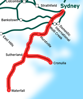
This is a map of the Eastern Suburbs & Illawarra Line in Sydney, Australia, traced on this public domain map.
Licensing
I, the creator of this work, hereby release it into the public domain. This applies worldwide.
In case this is not legally possible,
I grant any entity the right to use this work for any purpose, without any conditions, unless such conditions are required by law.
File history
Click on a date/time to view the file as it appeared at that time.
| Date/Time | Thumbnail | Dimensions | User | Comment | |
|---|---|---|---|---|---|
| current | 06:45, 16 February 2007 | | 278 × 334 (59 KB) | Admin (talk | contribs) | == Summary == This is a map of the Eastern Suburbs & Illawarra Line in Sydney, Australia, traced on this public domain map. == Licensing == {{PD-self}} Category:CityRail Sydney Category:Railroad maps |
- You cannot overwrite this file.
File usage
The following page links to this file:
