File:CityNightLine Map.gif

Summary
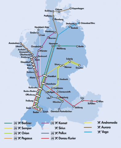
This is a map of all the lines of CityNightLine AG in 2006. [1]
Licensing

This work is copyrighted and unlicensed. It does not fall into one of the blanket fair use categories listed at Project:Fair use#Images or Project:Fair use#Audio_clips. However, it is believed that the use of this work in the article "CityNightLine":
- To illustrate the object in question
- Where no free equivalent is available or could be created that would adequately give the same information
- on the English-language Spotting World, hosted on servers globally,
qualifies as fair use under United States copyright law. Other use of this image, on Spotting World or elsewhere, may be copyright infringement.
To the uploader: this tag is not a sufficient claim of fair use. You must also include the source of the work, all available copyright information, and a detailed fair use rationale.
Fair use rationale: No free alternative known at the time, serves for illustrating the CityNightLine network.
File history
Click on a date/time to view the file as it appeared at that time.
| Date/Time | Thumbnail | Dimensions | User | Comment | |
|---|---|---|---|---|---|
| current | 22:42, 15 February 2007 | | 480 × 586 (245 KB) | Admin (talk | contribs) | == Summary == This is a map of all the lines of CityNightLine AG in 2006. [http://www.citynightline.ch/-S:PtVOSN:eSlklNNNU@f57tNNNXIM/citynightline/view/fahrplan/streckennetz/eng_streckennetz.shtml] == Licensing == {{Fair use in|CityNightLine}} Fair use rationale: No free alternative known at the time, serves for illustrating the CityNightLine network. |
- You cannot overwrite this file.
File usage
The following page links to this file:
