File:1921 Chicago L map.jpg
From TrainSpottingWorld, for Rail fans everywhere
Size of this preview: 570 × 480 pixels. Other resolutions: 285 × 240 pixels | 3,029 × 2,550 pixels.
Original file (3,029 × 2,550 pixels, file size: 5.7 MB, MIME type: image/jpeg)
| Description |
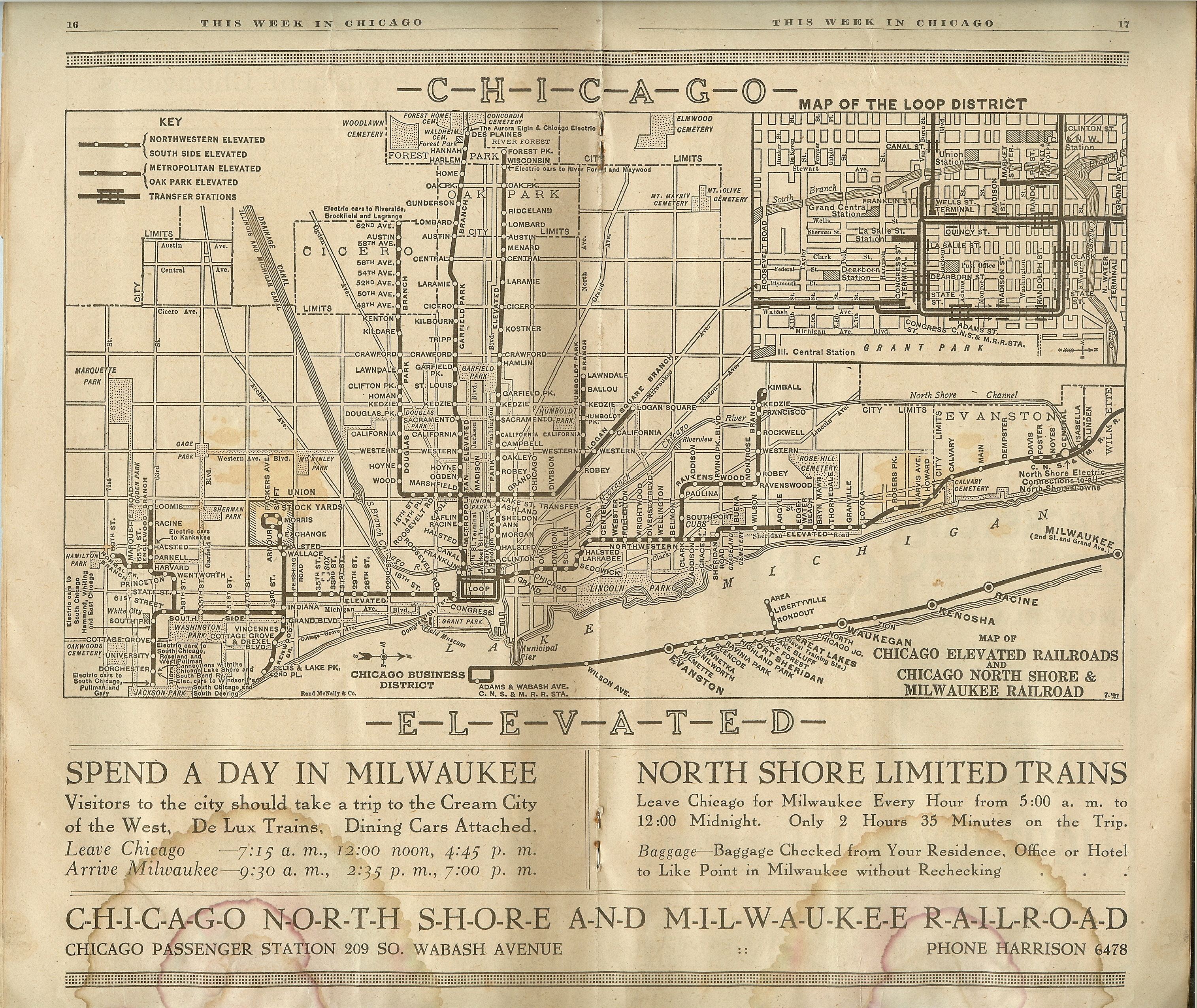
Map found in a Chicago guidebook called "This Week in Chicago" dated Sept. 4–Sept. 10, 1921—carries the notations "Rand McNally & Co." and "7-'21." | ||
|---|---|---|---|
| Source |
"This Week in Chicago" Sept. 4–Sept. 10, 1921. Originally uploaded to en.wikipedia by wp:User:Edzotti.
| ||
| Date |
1921 | ||
| Author |
unknown | ||
| Permission (Reusing this image) |
Public Domain |
Licensing
This image is in the public domain in the United States. In most cases, this means that it was first published in the United States prior to January 1, 1923 . Other jurisdictions may have other rules, and this image might not be in the public domain outside the United States. See public domain and Copyrights for more details.
File history
Click on a date/time to view the file as it appeared at that time.
| Date/Time | Thumbnail | Dimensions | User | Comment | |
|---|---|---|---|---|---|
| current | 06:36, 16 February 2007 | | 3,029 × 2,550 (5.7 MB) | Admin (talk | contribs) | {{Information |Description=Map found in a Chicago guidebook called "This Week in Chicago" dated Sept. 4–Sept. 10, 1921—carries the notations "Rand McNally & Co." and "7-'21." |Source="This Week in Chicago" Sept. 4–Sept. 10, 1921. Originally uploaded to en.wikipedia by w:User:Edzotti |Date=1921 |Author= |Permission=Public Domain }} ==Licensing== {{PD-US}} Category:Chicago from 1900 to 1939 Category:Chicago 'L' Category:Historical maps of Chicago Category:1921 |
- You cannot overwrite this file.
File usage
The following page links to this file:
