File:Rugby-Stafford rail routes.png
Summary
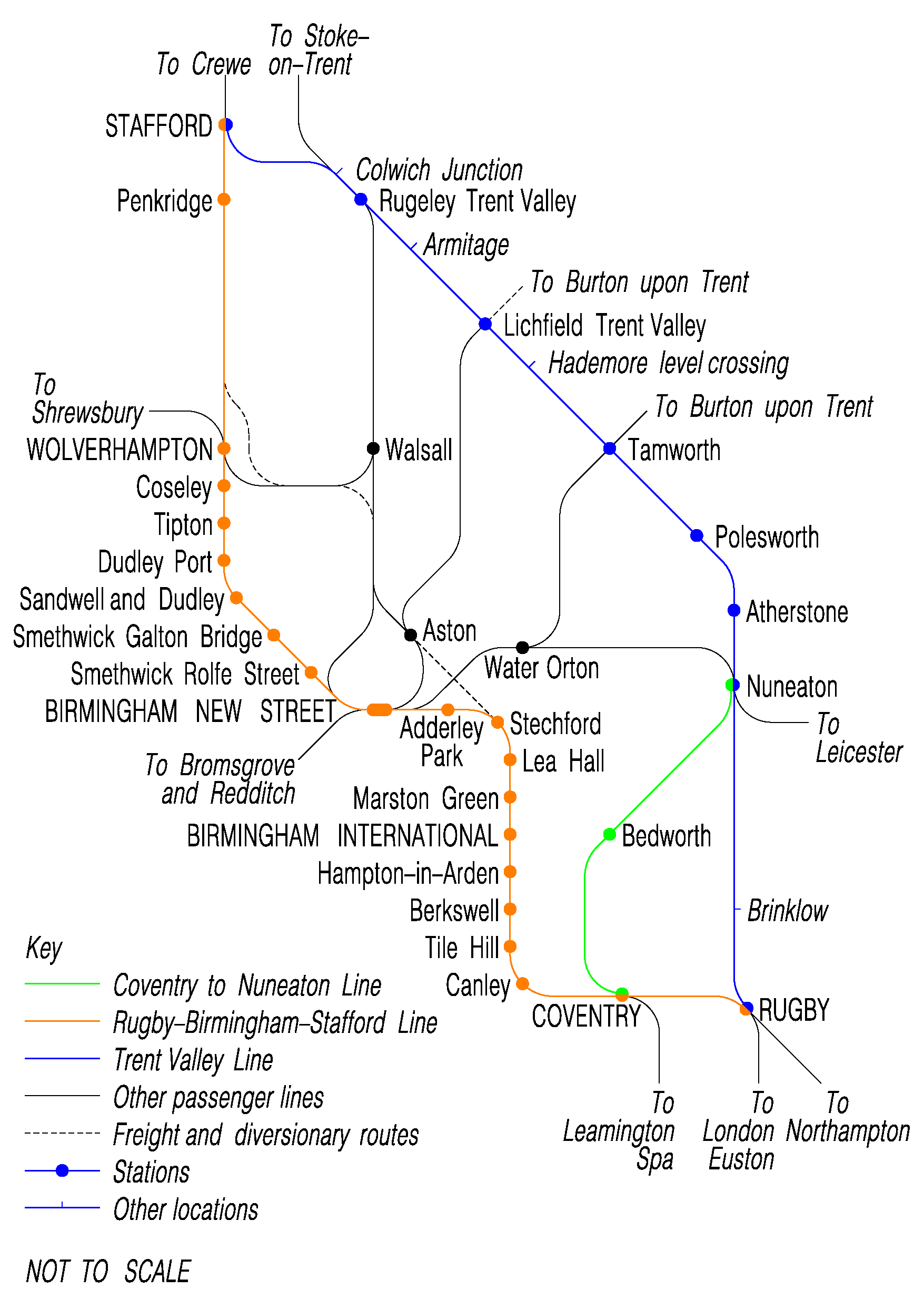
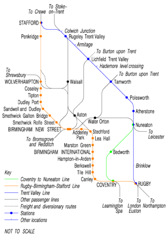
Diagrammatic map of the following rail routes in the West Midlands:
Other lines, to indicate connections between these routes.
All stations on the above three lines are shown. On other lines, only certain junction stations are shown. Some lines (for example lines from Birmingham Snow Hill) are omitted for clarity.
Some intermediate locations are shown on the Trent Valley Line where described in the text of that article.
Technical details
This image was created using Bentley Microstation, and exported as a pdf document. This in turn was exported in PNG format using Adobe Acrobat professional. The image size is 297mm x 420mm (A3) at a resolution of 150 dpi.
Licensing
This image has been (or is hereby) released into the public domain by its creator, Tivedshambo. This applies worldwide.
In case this is not legally possible,
the creator grants anyone the right to use this work for any purpose, without any conditions, unless such conditions are required by law.
Subject to disclaimers.
References
- Rail Atlas of Great Britain & Ireland, 10th edition, S. K Baker (ISBN 0-86093-576-0)
- Railway Track Diagrams: Midlands & North West, 2nd edition, edited by Gerald Jacobs (ISBN 0-9549866-0-1)
See also
See other images from this contributor.
File history
Click on a date/time to view the file as it appeared at that time.
| Date/Time | Thumbnail | Dimensions | User | Comment | |
|---|---|---|---|---|---|
| current | 22:48, 15 February 2007 | | 1,755 × 2,482 (204 KB) | Admin (talk | contribs) | {{SVG}} == Summary == Diagrammatic map of the following rail routes in the West Midlands: *Coventry to Nuneaton Line *Rugby-Birmingham-Stafford Line *Trent Valley Line Other lines, to indicate connections between these routes. All stations on the above three lines are shown. On other lines, only certain junction stations are shown. Some lines (for example lines from Birmingham Snow Hill) are omitted for clarity. Some intermediate locations are shown on the Trent Valley Line where described in the text of that article. == Technical details == This image was created using Bentley Microstation, and exported as a pdf document. This in turn was exported in PNG format using Adobe Acrobat professional. The image size is 297mm x 420mm (A3) at a resolution of 150 dpi. == Licensing == {{PD-user|Tivedshambo}} == References == *''Rail Atlas of Great Britain & Ireland'', 10th edition, S. K Baker (ISBN 0-86093-576-0) *''Railway Track Diagrams: Midlands & North West'', 2nd edition, edited by Gerald Jacobs (ISBN 0-9549866-0-1) == See also == See other images from this contributor. |
- You cannot overwrite this file.
File usage
The following 4 pages link to this file:
