File:Maps-skarloey-railway-amoswolfe.png
From TrainSpottingWorld, for Rail fans everywhere
Size of this preview: 269 × 479 pixels. Other resolutions: 135 × 240 pixels | 320 × 570 pixels.
Original file (320 × 570 pixels, file size: 67 KB, MIME type: image/png)
Summary

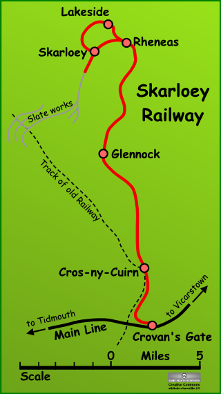
Map of the fictional Skarloey Railway on the Island of Sodor, from The Railway Series by Rev. W. Awdry.
Drawn by AmosWolfe on 11th September 2005, using the software package Serif DrawPlus.
A number of different maps of this island, including an original painted by Rev. Awdry can be found on this excellent website.
The source file is available as a scaleable vector on request, subject to the licence below.
Licensing
| This image is licensed under the Creative Commons Attribution ShareAlike License v. 2.5: http://creativecommons.org/licenses/by-sa/2.5/ |
File history
Click on a date/time to view the file as it appeared at that time.
| Date/Time | Thumbnail | Dimensions | User | Comment | |
|---|---|---|---|---|---|
| current | 00:58, 16 February 2007 | | 320 × 570 (67 KB) | Admin (talk | contribs) | == Summary == thumb|250px|A map of the Island of Sodor showing the Railway system (click to enlarge). Map of the fictional Skarloey Railway on the Island of Sodor, from The Railway Series by Rev. W. Awdry. Drawn by AmosWolfe on 11th September 2005, using the software package Serif DrawPlus. A number of different maps of this island, including an original painted by Rev. Awdry can be found on [http://www.pegnsean.net/~railwayseries/mapsection.htm this excellent website]. The source file is available as a scaleable vector on request, subject to the licence below. Category:Fictional maps == Licensing == {{cc-by-sa-2.5}} |
- You cannot overwrite this file.
File usage
The following 2 pages link to this file:
