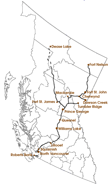
File:BC Rail map.png
From TrainSpottingWorld, for Rail fans everywhere
Size of this preview: 282 × 479 pixels. Other resolutions: 141 × 240 pixels | 373 × 634 pixels.
Original file (373 × 634 pixels, file size: 41 KB, MIME type: image/png)
Map of BC Rail. Background from Image:Bcmap.PNG, which is PD. Routes based on Lines of Country, Philip's Concise World Atlas, and CN's website. Copyright © 2005, James Yolkowski (wp:User:JYolkowski).

Permission is granted to copy, distribute and/or modify this document under the terms of the GNU Free Documentation License, Version 1.2 or any later version published by the Free Software Foundation; with no Invariant Sections, no Front-Cover Texts, and no Back-Cover Texts.
Subject to disclaimers.
File history
Click on a date/time to view the file as it appeared at that time.
| Date/Time | Thumbnail | Dimensions | User | Comment | |
|---|---|---|---|---|---|
| current | 04:14, 16 February 2007 | | 373 × 634 (41 KB) | Admin (talk | contribs) | Map of BC Rail. Background from Image:Bcmap.PNG, which is PD. Routes based on ''Lines of Country'', ''Philip's Concise World Atlas'', and CN's website. Copyright © 2005, James Yolkowski (wp:User:JYolkowski).{{GFDL}} |
- You cannot overwrite this file.
File usage
The following page links to this file:
